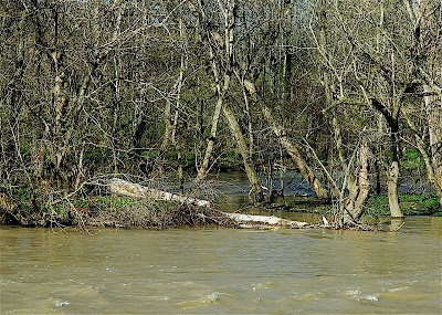
 This is a sort of follow-up to yesterday’s posting and its brief mention of the effects of upstream rain, with today’s view of the recently fallen snag I wrote about last Monday.[here]
 As you can see by comparing the two photos, the river is up. I’d guess about a 5-6 foot difference in the water level. Most of this rise occurred yesterday, from mid-morning onward. When I checked yesterday morning—and mentioned afterwards in my posting—the water was up no more than a few inches above what it had been prior to Friday night’s thundershowers. I speculated then that the real effects of the storm and the amount the water level might subsequently rise, would depend on how much rain fell upstream, in the river’s upper drainage area to the north and northwest of here.
Upstream rain is always the critical criteria for any riverside dweller; rain sluicing down upon our home stretch of river matters not a whit to the stream’s level, though it could be disastrous to those who live farther downstream.
While this high-water view might cause one to conclude that upstream rainfall had been substantial…judging from past experience, I’d say probably not. I base that on the river’s slow rise. I’ve seen it reach this level within an hour following a drenching storm—and yes, that’s scary!
This time, I’d say we’re just now seeing a fairly modest rain which fell on the drainage basin’s woods, fields, and farmlands, found its way into ditches and tiny tributaries, then into brooks and small feeder creeks, and drained on into mainstream of the river. From here the water will soon join an even larger river, which will itself empty into the Ohio River, get dumped into the Mississippi, and thence into the Gulf of Mexico after something like a week of downhill travel time.
Another point—if you look at the two photos and compare the width of the island between views (see the water just over there, through the trees) you’ll notice how much narrower the dry land mass has temporarily become. The distance in the low-water shot from the near bank to the island’s far edge is approximately 75 feet. The island is about 400 feet long, and is one of several, all equally long and skinny, strung like the white-line center dashes marking a highway lane. In the high-water shot, that width is reduced to about half, maybe 35 feet.
You can also see one of the low transverse areas which, during times of high water, allow the two channels to merge, temporarily sub-dividing the single island into three or four shorter islands. Note a large section of the fallen snag is lying in this now-flooded low area. That’s why I speculated the downed trunk might not be around following a rise in the river. We’ll see about that…though so far the old stub is hanging tough and staying in place.
Perhaps you might wonder what island wildlife other than birds do during high water periods? Well, the fox squirrels have no problem; they simply imitate their gray cousins and take to the treetops, foraging on bud tips or whatever other edibles the season offers. I presume coons, possums, and skunks either abandon ship or den up, snug and dry, in of the many hollow sycamores.
I’ve have seen deer become marooned for several days. The normal depth the water in the channel beyond the island is, in places, less than knee deep. Consequently, as the water begins to come up, even with a fast rise, there’s usually plenty of time to make an escape. But wait too long to move to the mainland, and they find themselves having to decide whether to swim for it, or stay stuck until the water levels lowers.
For any deer which does manage to get themselves stuck, there’s a fair amount of browse available on the island, so food for a few days usually isn’t a problem. What can be a problem, of course, is getting caught on a rise where the water comes up even higher than pictured here.
Once, the winter after I moved to this riverside cottage, a pair of whitetails became stranded on the island as the water rose to a point as high as I’ve yet witnessed. Fortunately, there’s a little knob at the island’s upstream tip that rises about eight feet higher than the land you see here. This became the deer’s home—a tiny island about 20 by 30 feet, or about the size of my cottage’s great room; yet a sufficient and safe enough refuge, nevertheless. The whitetails selected a sunny spot to bed down, out of the wind and facing upstream, and simply waited. Of course, there wasn’t much else they could do or anywhere else to go. While they probably got hungry during their ordeal, both deer made it off a few days later.
The next twenty-four hours will confirm whether my guess on the water’s rise proves correct. It will also reveal (for this round of high water, anyway) the old snag’s fate…stay or go. I’ll keep you posted.
As you can see by comparing the two photos, the river is up. I’d guess about a 5-6 foot difference in the water level. Most of this rise occurred yesterday, from mid-morning onward. When I checked yesterday morning—and mentioned afterwards in my posting—the water was up no more than a few inches above what it had been prior to Friday night’s thundershowers. I speculated then that the real effects of the storm and the amount the water level might subsequently rise, would depend on how much rain fell upstream, in the river’s upper drainage area to the north and northwest of here.
Upstream rain is always the critical criteria for any riverside dweller; rain sluicing down upon our home stretch of river matters not a whit to the stream’s level, though it could be disastrous to those who live farther downstream.
While this high-water view might cause one to conclude that upstream rainfall had been substantial…judging from past experience, I’d say probably not. I base that on the river’s slow rise. I’ve seen it reach this level within an hour following a drenching storm—and yes, that’s scary!
This time, I’d say we’re just now seeing a fairly modest rain which fell on the drainage basin’s woods, fields, and farmlands, found its way into ditches and tiny tributaries, then into brooks and small feeder creeks, and drained on into mainstream of the river. From here the water will soon join an even larger river, which will itself empty into the Ohio River, get dumped into the Mississippi, and thence into the Gulf of Mexico after something like a week of downhill travel time.
Another point—if you look at the two photos and compare the width of the island between views (see the water just over there, through the trees) you’ll notice how much narrower the dry land mass has temporarily become. The distance in the low-water shot from the near bank to the island’s far edge is approximately 75 feet. The island is about 400 feet long, and is one of several, all equally long and skinny, strung like the white-line center dashes marking a highway lane. In the high-water shot, that width is reduced to about half, maybe 35 feet.
You can also see one of the low transverse areas which, during times of high water, allow the two channels to merge, temporarily sub-dividing the single island into three or four shorter islands. Note a large section of the fallen snag is lying in this now-flooded low area. That’s why I speculated the downed trunk might not be around following a rise in the river. We’ll see about that…though so far the old stub is hanging tough and staying in place.
Perhaps you might wonder what island wildlife other than birds do during high water periods? Well, the fox squirrels have no problem; they simply imitate their gray cousins and take to the treetops, foraging on bud tips or whatever other edibles the season offers. I presume coons, possums, and skunks either abandon ship or den up, snug and dry, in of the many hollow sycamores.
I’ve have seen deer become marooned for several days. The normal depth the water in the channel beyond the island is, in places, less than knee deep. Consequently, as the water begins to come up, even with a fast rise, there’s usually plenty of time to make an escape. But wait too long to move to the mainland, and they find themselves having to decide whether to swim for it, or stay stuck until the water levels lowers.
For any deer which does manage to get themselves stuck, there’s a fair amount of browse available on the island, so food for a few days usually isn’t a problem. What can be a problem, of course, is getting caught on a rise where the water comes up even higher than pictured here.
Once, the winter after I moved to this riverside cottage, a pair of whitetails became stranded on the island as the water rose to a point as high as I’ve yet witnessed. Fortunately, there’s a little knob at the island’s upstream tip that rises about eight feet higher than the land you see here. This became the deer’s home—a tiny island about 20 by 30 feet, or about the size of my cottage’s great room; yet a sufficient and safe enough refuge, nevertheless. The whitetails selected a sunny spot to bed down, out of the wind and facing upstream, and simply waited. Of course, there wasn’t much else they could do or anywhere else to go. While they probably got hungry during their ordeal, both deer made it off a few days later.
The next twenty-four hours will confirm whether my guess on the water’s rise proves correct. It will also reveal (for this round of high water, anyway) the old snag’s fate…stay or go. I’ll keep you posted.

 This is a sort of follow-up to yesterday’s posting and its brief mention of the effects of upstream rain, with today’s view of the recently fallen snag I wrote about last Monday.[here]
 As you can see by comparing the two photos, the river is up. I’d guess about a 5-6 foot difference in the water level. Most of this rise occurred yesterday, from mid-morning onward. When I checked yesterday morning—and mentioned afterwards in my posting—the water was up no more than a few inches above what it had been prior to Friday night’s thundershowers. I speculated then that the real effects of the storm and the amount the water level might subsequently rise, would depend on how much rain fell upstream, in the river’s upper drainage area to the north and northwest of here.
Upstream rain is always the critical criteria for any riverside dweller; rain sluicing down upon our home stretch of river matters not a whit to the stream’s level, though it could be disastrous to those who live farther downstream.
While this high-water view might cause one to conclude that upstream rainfall had been substantial…judging from past experience, I’d say probably not. I base that on the river’s slow rise. I’ve seen it reach this level within an hour following a drenching storm—and yes, that’s scary!
This time, I’d say we’re just now seeing a fairly modest rain which fell on the drainage basin’s woods, fields, and farmlands, found its way into ditches and tiny tributaries, then into brooks and small feeder creeks, and drained on into mainstream of the river. From here the water will soon join an even larger river, which will itself empty into the Ohio River, get dumped into the Mississippi, and thence into the Gulf of Mexico after something like a week of downhill travel time.
Another point—if you look at the two photos and compare the width of the island between views (see the water just over there, through the trees) you’ll notice how much narrower the dry land mass has temporarily become. The distance in the low-water shot from the near bank to the island’s far edge is approximately 75 feet. The island is about 400 feet long, and is one of several, all equally long and skinny, strung like the white-line center dashes marking a highway lane. In the high-water shot, that width is reduced to about half, maybe 35 feet.
You can also see one of the low transverse areas which, during times of high water, allow the two channels to merge, temporarily sub-dividing the single island into three or four shorter islands. Note a large section of the fallen snag is lying in this now-flooded low area. That’s why I speculated the downed trunk might not be around following a rise in the river. We’ll see about that…though so far the old stub is hanging tough and staying in place.
Perhaps you might wonder what island wildlife other than birds do during high water periods? Well, the fox squirrels have no problem; they simply imitate their gray cousins and take to the treetops, foraging on bud tips or whatever other edibles the season offers. I presume coons, possums, and skunks either abandon ship or den up, snug and dry, in of the many hollow sycamores.
I’ve have seen deer become marooned for several days. The normal depth the water in the channel beyond the island is, in places, less than knee deep. Consequently, as the water begins to come up, even with a fast rise, there’s usually plenty of time to make an escape. But wait too long to move to the mainland, and they find themselves having to decide whether to swim for it, or stay stuck until the water levels lowers.
For any deer which does manage to get themselves stuck, there’s a fair amount of browse available on the island, so food for a few days usually isn’t a problem. What can be a problem, of course, is getting caught on a rise where the water comes up even higher than pictured here.
Once, the winter after I moved to this riverside cottage, a pair of whitetails became stranded on the island as the water rose to a point as high as I’ve yet witnessed. Fortunately, there’s a little knob at the island’s upstream tip that rises about eight feet higher than the land you see here. This became the deer’s home—a tiny island about 20 by 30 feet, or about the size of my cottage’s great room; yet a sufficient and safe enough refuge, nevertheless. The whitetails selected a sunny spot to bed down, out of the wind and facing upstream, and simply waited. Of course, there wasn’t much else they could do or anywhere else to go. While they probably got hungry during their ordeal, both deer made it off a few days later.
The next twenty-four hours will confirm whether my guess on the water’s rise proves correct. It will also reveal (for this round of high water, anyway) the old snag’s fate…stay or go. I’ll keep you posted.
As you can see by comparing the two photos, the river is up. I’d guess about a 5-6 foot difference in the water level. Most of this rise occurred yesterday, from mid-morning onward. When I checked yesterday morning—and mentioned afterwards in my posting—the water was up no more than a few inches above what it had been prior to Friday night’s thundershowers. I speculated then that the real effects of the storm and the amount the water level might subsequently rise, would depend on how much rain fell upstream, in the river’s upper drainage area to the north and northwest of here.
Upstream rain is always the critical criteria for any riverside dweller; rain sluicing down upon our home stretch of river matters not a whit to the stream’s level, though it could be disastrous to those who live farther downstream.
While this high-water view might cause one to conclude that upstream rainfall had been substantial…judging from past experience, I’d say probably not. I base that on the river’s slow rise. I’ve seen it reach this level within an hour following a drenching storm—and yes, that’s scary!
This time, I’d say we’re just now seeing a fairly modest rain which fell on the drainage basin’s woods, fields, and farmlands, found its way into ditches and tiny tributaries, then into brooks and small feeder creeks, and drained on into mainstream of the river. From here the water will soon join an even larger river, which will itself empty into the Ohio River, get dumped into the Mississippi, and thence into the Gulf of Mexico after something like a week of downhill travel time.
Another point—if you look at the two photos and compare the width of the island between views (see the water just over there, through the trees) you’ll notice how much narrower the dry land mass has temporarily become. The distance in the low-water shot from the near bank to the island’s far edge is approximately 75 feet. The island is about 400 feet long, and is one of several, all equally long and skinny, strung like the white-line center dashes marking a highway lane. In the high-water shot, that width is reduced to about half, maybe 35 feet.
You can also see one of the low transverse areas which, during times of high water, allow the two channels to merge, temporarily sub-dividing the single island into three or four shorter islands. Note a large section of the fallen snag is lying in this now-flooded low area. That’s why I speculated the downed trunk might not be around following a rise in the river. We’ll see about that…though so far the old stub is hanging tough and staying in place.
Perhaps you might wonder what island wildlife other than birds do during high water periods? Well, the fox squirrels have no problem; they simply imitate their gray cousins and take to the treetops, foraging on bud tips or whatever other edibles the season offers. I presume coons, possums, and skunks either abandon ship or den up, snug and dry, in of the many hollow sycamores.
I’ve have seen deer become marooned for several days. The normal depth the water in the channel beyond the island is, in places, less than knee deep. Consequently, as the water begins to come up, even with a fast rise, there’s usually plenty of time to make an escape. But wait too long to move to the mainland, and they find themselves having to decide whether to swim for it, or stay stuck until the water levels lowers.
For any deer which does manage to get themselves stuck, there’s a fair amount of browse available on the island, so food for a few days usually isn’t a problem. What can be a problem, of course, is getting caught on a rise where the water comes up even higher than pictured here.
Once, the winter after I moved to this riverside cottage, a pair of whitetails became stranded on the island as the water rose to a point as high as I’ve yet witnessed. Fortunately, there’s a little knob at the island’s upstream tip that rises about eight feet higher than the land you see here. This became the deer’s home—a tiny island about 20 by 30 feet, or about the size of my cottage’s great room; yet a sufficient and safe enough refuge, nevertheless. The whitetails selected a sunny spot to bed down, out of the wind and facing upstream, and simply waited. Of course, there wasn’t much else they could do or anywhere else to go. While they probably got hungry during their ordeal, both deer made it off a few days later.
The next twenty-four hours will confirm whether my guess on the water’s rise proves correct. It will also reveal (for this round of high water, anyway) the old snag’s fate…stay or go. I’ll keep you posted.
